


“USA 🇺🇸 Arizona ~Tucson at Saguaro National Park Red Hills/West and Rincon Mountain/East”

Saguaro National Park
There are actually two parts to this National Park, and they are 30 miles apart.
The two districts are: The Rincon Mountain, located to the East of Tucson, Arizona and the Tucson Mountain District of Red Hills, which is located to the West of Tucson.
In 1933 Saguaro National Monument was created. The Saguaro Wilderness Area of 71,400 acres was added in 1975. Saguaro National Park was created from these areas in 1994, and currently encompasses 91,327 acres in its two districts.
On our first outing, we went to the furthest away part for us, which was the Red Hills in the West District.

This visit was plenty for one day, so we chose to do the East part, the next day.

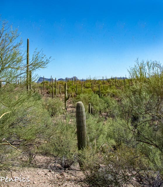
WEST ~Red Hills


I just loved our fun day!
We got up early, thinking we would beat the heat of the day, to visit Saguaro National Park. (Pronounced Say-arrow)

The Western Tucson Mountain District is generally lower in elevation with a denser saguaro forest, compared to the East.
We didn’t exactly beat the heat, because it’s just super hot, even though it’s fall, but we took a short hike anyway, to check out some ancient petroglyphs.
We drove directly to Signal Hill, where there is parking and a trailhead for the petroglyphs. We were both surprised the road to this trailhead was gravel. Luckily, this road wasn’t too bad.

The trick in the desert, is to stay hydrated: one, and two; Wear a brimmed hat, and three: watch out for Rattlesnakes The snakes don’t like the direct heat of the sun anymore than humans do, whilst in the desert, so no problems this time of year on the trail. BUT, don’t go nosing around in the shade of the rocks, shrubs, and cactus, without taking caution.


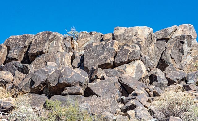


Prehistoric Rock Art
Petroglyphs
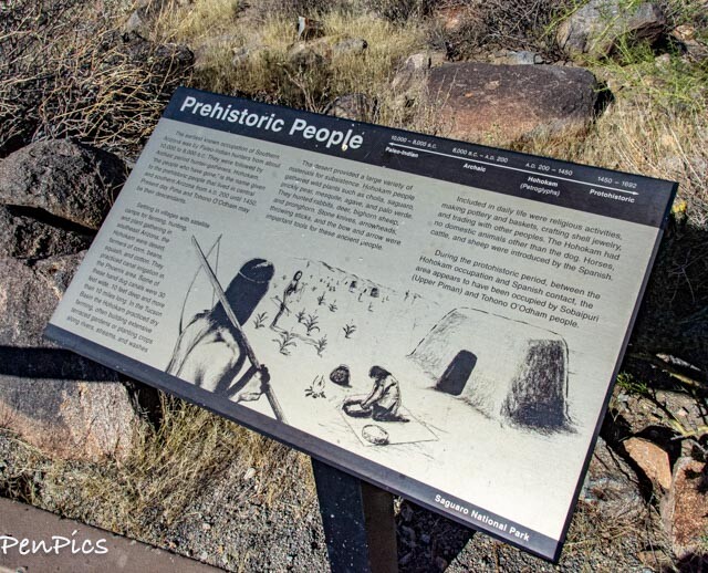
The rock art found within Saguaro National Park was created by the prehistoric Hohokam people.
The Hohokam may have created these petroglyphs more than a thousand years ago while on hunting and gathering expeditions. As more is discovered about these Petroglyphs, there is better understanding of the Hohokam culture.
Rock art is found throughout the American Southwest, wherever prehistoric peoples lived, or journeyed. At Saguaro National Park, many expressions of rock art, known as petroglyphs, were created.
People do not know exactly what these petroglyphs mean. They could have religious or ceremonial significance. They may be solstice markers, clan symbols, decorative motifs, or simply ancient graffiti.


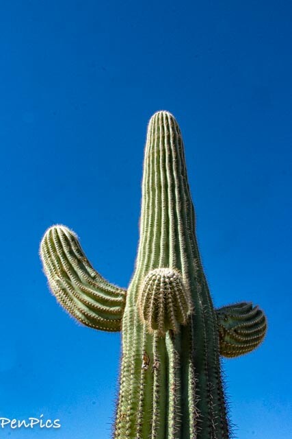
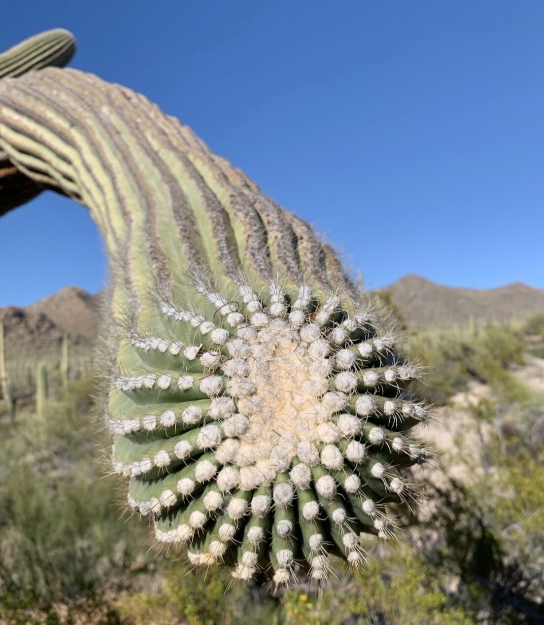
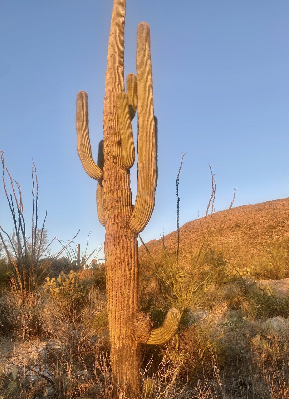
The Giant Saguaro is the most fascinating plant of the Sonoran Desert. Its skin is tough and waxy and its woody skeleton is concealed inside the plant. The trunk and arms are pleated like an accordion and are 80 to 90 percent water, when filled. Sixty percent of the saguaro’s water content can be lost without causing damage.
In the place of leaves, the Saguaro has thousands of spines to shade and protect itself.

Saguaro roots extend to a diameter of 100 feet (for a 50-foot-high Saguaro) at a depth of only inches. Tiny hairs absorb even concentrated drizzle or mist.

The Saguaro 🌵 are protected under the Native Plant Protection Act. If a person is caught cutting down a saguaro it is actually considered a felony and criminal charges can result in 25 years in prison.
Any other type of vandalism, theft and attempts to transplant the cactus will also result in pricey fees and jail time.

Tucson, Arizona is home to the nation’s largest cacti. These giant Saguaro are the universal symbol of the American west.
These majestic plants, found only in a small portion of the United States; mostly in the Sonora Desert, are protected by Saguaro National Park, to the east and west of the modern city of Tucson.


An adult Saguaro is generally considered to be about 125 years of age. It may weigh 6 tons or more, and be as tall as 50 feet.
The average life span of a saguaro is probably 150 – 175 years of age. However, biologists believe that some plants may live over 200 years.
It is interesting to note, the arms of the Saguaro 🌵 take at least 50 years to begin growing. There are cases where a Saguaro will not produce any arms, ever.


There was one Scenic Loop on the map, called Bajada, we wanted to go on, but it was not doable at all. There were chunky rocks; exposed and partially embedded. I’ve never seen anything like it in a National Park. Oh well. We stuck to the paved roads after our hike and drove all over, and enjoyed it very much!
We actually made a gigantic loop in a way, coming off of I-10 going West. Then, when we were done for the day, we drove out of the Park by the opposite end, from where we came in at, and looped around back to I-10. It was a longer way to go, but so beautiful! We even saw a Road Runner speed in front of us on the road. Those are cool-looking birds.
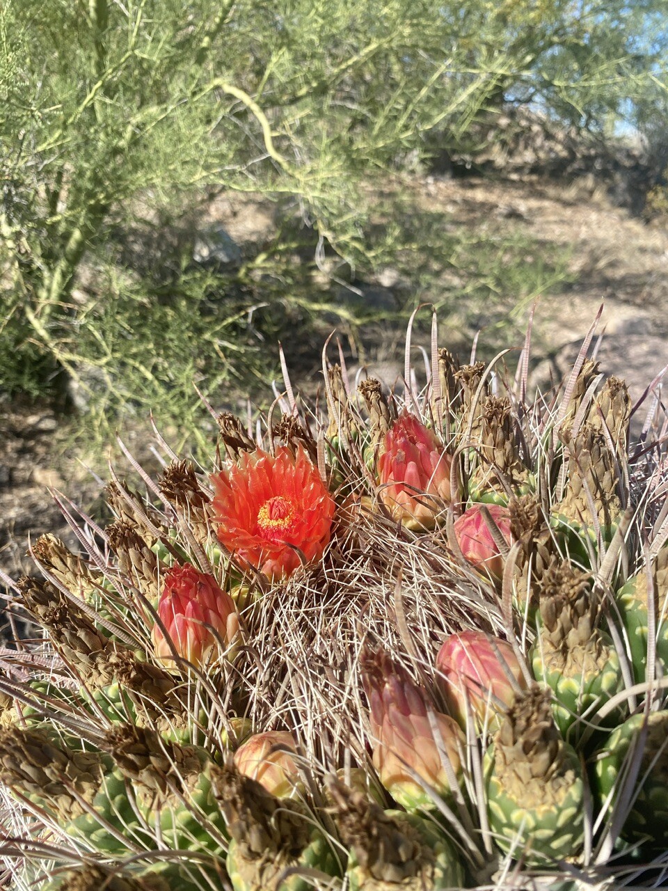
I’m already looking forward to the East side, tomorrow, to explore more of the Park! As I mentioned before, Saguaro 🌵 are just “extra” for me and make the desert come alive. I bet in the spring the desert blooms are beautiful, too!


Heading out of the Park, and back to The Whale

************
We found a great Thai place a few exits away on I-10 and chowed down.
LUCKIES THAI-ASIAN
Yum! ⬇️

*************
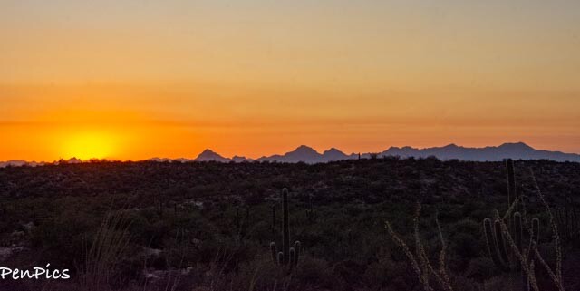
EAST ~Rincon Mountain

The Eastern Rincon Mountain District includes over 128 miles of trails, and is the larger and more remote of the two halves of the preserve, and includes an extensive mountainous area, with hills as high as 8,664 feet, which would be Mica Mountain.
Once I confirmed the 8-mile Cactus Forest Drive Scenic Loop was paved, we decided to go in the late afternoon to try to get some sunset photos with the famous Saguaro Cacti 🌵 landscape:
Various online sites for this National Park say the gate closes at 5PM. Given sunset isn’t until 6PM, I wasn’t sure if sunset photos were in the cards for us, there.
I finally called the visitor’s center and was told the gate stays open till 8PM. AND, one can remain in the park, if already inside, before the gate closes; as the gate has an automatic system and will open to allow a departure.

The cacti here are as large, but grow slightly less dense than those at Red Hills in West Saguaro National Park, with more intervening bushes and other vegetation.


It is written, that if faced with having to choose between one district or the other, due to time constraints, the West is preferable for a short visit, though the east offers many more opportunities for extended hiking, and is the only region where backpacking is permitted. I’m glad we didn’t have to choose, and had the time and opportunity to see both locations.
They are equally, beautiful and magnificent!


From the East park entrance at the junction of Freeman Road and the Old Spanish Trail, a paved one-way road (the 8-mile Cactus Forest Drive) loops over undulating land and gives a good impression of the landscape, especially the southern section which climbs a little and passes over foothills of the west-end of Tanque Verde Ridge, where the Saguaro are especially plentiful since they prefer gently sloping ground with better drainage.
The Cactus Forest Drive is what we did, as the view at the highest peak is said to best for sunset photos. The Loop was completely resurfaced some years ago, and now has improved parking areas and 12 new roadside exhibits. We found driving the complete circuit took around 20 minutes, if not making any stops.
Along the way are two short spur roads to picnic areas/trailheads; Javelina (paved) and Mica View (unpaved). We stuck to the paced sections of the park.


In the highest elevation, there are fewer Saguaro Cacti, but there are Black Bears that reside up there, but they seldom come down to the lower elevation.


🤣

We ended up doing the gorgeous 8-mile loop, two times; first, just to enjoy the beauty of it all, but also to figure out where we would eventually park and wait for the sunset. It’s a one-way loop, so there is no turning around to backtrack.
We picked a large outcropping of boulders, which provided shaded parking. It was perfect!
Sunset was at 6:09PM


So we waited about 40 minutes, hanging out in the shade, and enjoyed watching the changing light throw various colors over the landscape, as the sun went down. 
It was a magical time to witness such beauty in the desert!


Additional iPhone Photos ⬇️


As soon as the sun went down, it got dark real fast. We made our way back to Jonah and drove out of the park, enjoying every second of lasting light, signaling days end.


It was hot and windy today, but perfect in every way!

Nest Stop: Tombstone!!
************

ARIZONA
Archive Blog Posts of Our Country Visits
About Us

About Us
Hello and Welcome to our Travel Blog Website, We enjoy writing about our experiences and taking photos of our adventuring along the way. Our names are: Daryl and Pen, but Daryl calls me “Bunny.” We met, quite randomly, whilst both… Read More